Today's Kapa`a Quarry occupies the former site of the ancient stone adze quarry of the same name. [NOTE: this connection refers to the original quarry in Kapa`a Valley, since filled by the City & County municipal waste landfill known as Kapa`a Landfill]. The Hawaiian civilization depended upon the stone adze as a construction tool to produce religious images, build homes and houses of worship, produce agricultural tools, manufacture weapons of war, and carve and shape the all-important fishing canoes and the impressively large double-hulled voyaging canoes which attained lengths of 120 feet and more.1
Located in this valley is a heiau situated just above the original site of the old adze quarry. It is a large, walled structure measuring approximately 120 feet by 180 feet with an adjoining structure on the northern wall of 32 feet by 38 feet. Clearing and cleaning of the site was overseen by Ameron in 1988 and the site remains under the respectful care-taking of the company. Said to have been built by the legendary chief Olopana, this heiau is known today as Pahukini ("many drums"). However, it was also known by some informants as Mo`okini ("many lineages") and also Makini ("many deaths as a contraction of make kini). The second and third names suggest that this heiau was of the class designation as po`okanaka, translated as human head or skull -- that Pahukini (or Mo`okini or Makini) functioned as a luakini or large heiau where ruling chiefs prayed and human sacrifices were offered.1


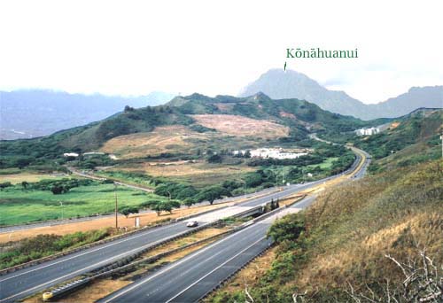
 Photo 1
- Looking into Kapa`a Valley from the vicinity of the Mokapu Saddle Road. A small portion of Kawai Nui Marsh and the Kapaa Quarry Road are evident beyond H-3 on the left. The closed City & County landfill occupies the center of the photograph.
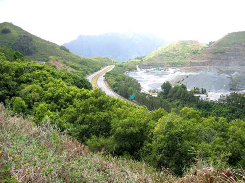
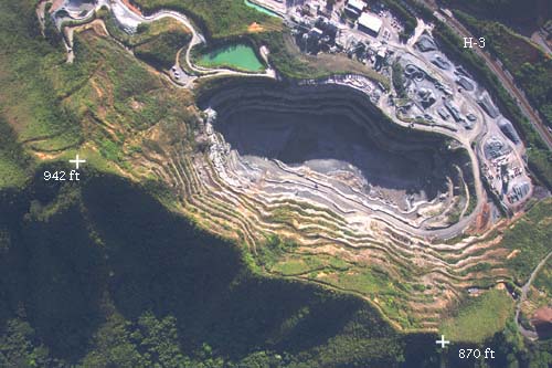
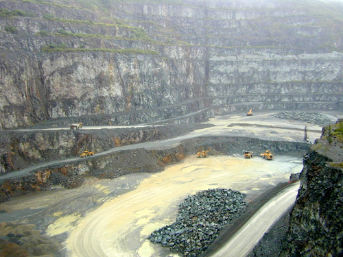
Because of the H-3 Interstate Highway, Kapa`a is familiar to most windward residents. This highway passes from Kane`ohe to Mokapu through Kapa`a Valley, from the saddle between Ulumawao and MahinuiA near Hawaii Pacific University to the Mokapu Saddle Road overpass. This four-lane now dominates the upper part of the valley, comprising some 13 acres (5.3 ha) or 2% of the watershed. The highway divides much of the area between the two principal land uses: the Ameron rock quarry operation on one side (Photographs 2, 3, & 4) and the City & County solid waste facilities on the other (Photograph 1). But the division is not perfect. In the upper valley, Ameron is developing its Phase II quarry operation on the slopes of Ulumawao across the freeway from existing Phase I; and, for a time, the slopes of Mahinui were used as the Kalaheo Landfill. This latter area is presently a commercial green-waste facility.
 Photo 2
- Looking towards the head end of Kapa`a Valley, with one of the peaks of Ulumawao on the left, the H-3 where it enters the upper end of Kapa`a Valley, and part of the Ameron quarry operation on the right.
- TMDL Sub-Basin descriptions (Kapa`a)
- Kapa`a Stream
- Ameron International
- Kapa`a Quarry by Lanikai School
- Kapaa Landfill Gas renewable energy project (HECO)
- Kapa`a Stream EPA TMDL Listing (1998)


 Photo 3.
- Vertical view looking down into the Ameron quarry (Phase I pit) in Kapa`a Valley. The forested land below the ridgeline at the bottom of the photograph is part of the watershed of Kawa Stream.
 Photo 4.
- Bottom of the Ameron quarry (Phase I) operation in Kapa`a. This quarry pit is the source of most of the construction aggregate used on O`ahu.